The SWMC Wiki is currently under review.
Talk:Ogmore Old
2nd Slab; Red line = A Tale of High Adventure - VS
Contents
Ogmore Familiarisation
Del and Alan - The OSM map here is pretty sparse regarding access details to the individual areas at Ogmore. I've spoken to Alan about this, but did you know that you can edit the OSM database to add areas and paths of interest. For example, check the Map on Hollow Top To Port Eynon. I've added individual crags to the database and also "permissive paths" accessing them.
If either of you require help getting started with editing OSM, then give me a shout. --Tim Hoddy 11:21, 3 June 2011 (BST)
I've got an Android (2.2) phone with GPS. What is a good app to begin to use to get stuff onto OSM? --Del 11:30, 3 June 2011 (BST)
- You can collect waypoints and tracks with your phone and you can use them to help you edit OSM database. There are three ways to do this (that I know of).
- The Web Interface (You'll need to set yourself up with an account). The web interface is not particularly powerful and I find it a bit of a bind to use. Much better is:-
- JOSM. You can work in layers, etc. It's a nice little interface (once you get used to it!!)
- Merkaator. Another OSM editor. Although its interface appears a little more agreeable, I foound that I liked JOSM better.
I actually use Viking together with JOSM. I look at my GPS tracks in viking and it helps me get an overall view before I commit edits to OSM.
If we can interest users into editing OSM, then I'll add something to th e Development page. There is a rather steep learning curve tho'.
I'm still at the stage of playing about with an app called 'OSMTracker for android'. I use some other apps too for logging runs, ect, usually with the intention of putting them on MapMyRun. I think OSMTracker will be the best app to get to grips with as it looks set to use offline maps from OSMAnd. You can also annotate. --Del 07:26, 17 June 2011 (BST)
Also Google 'My Tracks' does a good job too. However does anyone know what the legality is of then uploading the track to OSM? I'm doing my best to avoid atm. --Del 07:30, 17 June 2011 (BST)
- I cannot see why it should be illegal to upload a track that you made to OSM. You'd still have to edit the OSM database of course using one of the apps above, but you'd have your tracks to help you. --Tim Hoddy 08:26, 17 June 2011 (BST)
Ogmore Map
If you need to know where stuff is you could work it out from this for starters. I know where most of the ab points and cut off tidal points are too.--Alan rosier 11:52, 3 June 2011 (BST)

It could be done in OSM, but it would require a great deal of work to get that level of detail into OSM. For a start, the coastline would have to be edited and individual crags and footpaths would need to be mapped, all with a GPS.
Perhaps we could produce a static map using the current OSM as a base? I'm pretty sure that we cannot use edited static Google Maps owing to copyright difficulties. --Tim Hoddy 12:06, 3 June 2011 (BST)
I'm certain that Google will take action against us for using their data. I've found a few horror stories during my research - usually to do with phone apps. OSM seems the way forward as we can manipulate the data. The main problem with this is the steep learning curve you've already mentioned. --Del 12:20, 3 June 2011 (BST)
If OSM editing is going to prove too time consuming, we could, as I mentioned above. use a static map based on the current (or nearly current) OSM. All we could do is add the individula crags to OSM. That'd be easy, just send me the long/lat of each... We could then edit the maps to suit our own purposes, with say GIMP or Photo$hop. --Tim Hoddy 12:33, 3 June 2011 (BST)
Alan, I should be able to add individual crags to OSM if you supply a map as above but using Bing Maps instead. --Tim Hoddy 12:47, 3 June 2011 (BST)
Like this one?--Alan rosier 13:13, 3 June 2011 (BST)

Yep, that's the one. --Tim Hoddy 13:18, 3 June 2011 (BST)
Sorry to be a pain, but can you add the crag locations to it too? I tried to go from Google Map to OSM in JOSM but it was totally confusing and, I suspect, very prone to errors. --Tim Hoddy 14:08, 3 June 2011 (BST)
- Hold on... I see you've marked the crags but haven't named them. Will get the names from the other map. --Tim Hoddy 14:10, 3 June 2011 (BST)
- OK... I've added the crag locations to OSM, if you ok them, I'll add the long/lats to our Template:Googlemap and the individual crags should appear on our maps. It would also be good to produce a static map of the area using OSM as a base and editing with graphic packages. Crag locations should show up on OSM fairly soon. See OpenStreetMap. --Tim Hoddy 14:30, 3 June 2011 (BST)
- They're showing up now. remember to flush your browser's cache. --Tim Hoddy 14:32, 3 June 2011 (BST)
Err, how do i flush my casche?--Alan rosier 20:48, 3 June 2011 (BST)
- Dunno! --Tim Hoddy 00:35, 4 June 2011 (BST)
- In firefox there is a box to click when you clear the history; i.e. tools > clear recent history. However my browser (FF 4.0.1) seems to do it on a F5 refresh. --Del 10:50, 4 June 2011 (BST)
- I've now added more detail to the coastline as well... tho' that may well take a little longer to show up. --Tim Hoddy 14:42, 3 June 2011 (BST)
- See the following link for a suitable map for editing. Note the crag names but also note that my adjusted coastline is not rendering just yet. Will replace the image when it comes through. It's all a bit rough and ready but gives us some idea of what can be done. --Tim Hoddy 16:28, 3 June 2011 (BST)
- My edited (on OSM) coastline is taking longer to update than I thought. Should be ready soon tho' --Tim Hoddy 12:41, 5 June 2011 (BST)
- Just found out that coastline update happen only every 2 weeks with OSM Mapnik. --Tim Hoddy 08:53, 6 June 2011 (BST)
- The Mapnik coastline still hasn't been updated but I've managed to get Maperitive to get some reasonable output. It's here, should anyone wish to make a map from it. --Tim Hoddy 10:33, 16 June 2011 (BST)
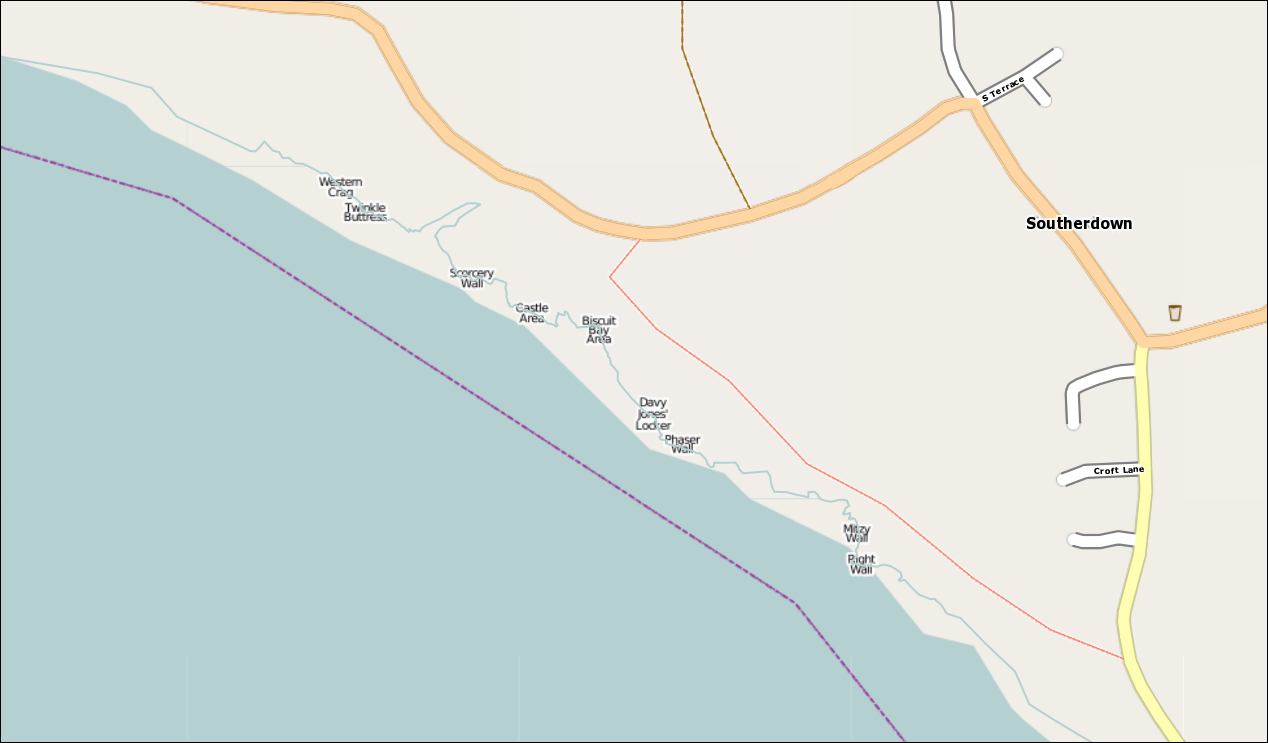
I can see it, you click on the top + (on right hand margin of the map) and select mapnik--Alan rosier 13:02, 16 June 2011 (BST)
- Yes, but the Mapnik rendering hasn't updated to my more detailed coastline yet... apparently coastline updates can take some time. --Tim Hoddy 13:06, 16 June 2011 (BST)
- Mapnik finally updated the coastline. Below is the Mapnik rendered OpenStreetMap data for the area. Please edit to show access paths, abseil points, other useful info, etc. --Tim Hoddy 10:58, 17 August 2011 (BST)

Ogmore Topos
I'm glad you said not to continue with Ogmore all that time ago. You have been busy! Well done Alan - a sterling effort! --Del 23:03, 3 June 2011 (BST)
Some of the topos might need checking (i.e. elephant wall goes right at the top?) but i'm sure you already know that? Might be best to get them printed out at some point and passed about perhaps. --Del 23:03, 3 June 2011 (BST)
Yeah, been meaning to. Apparently Elephant goes right but i think its a better route following the line on the topo.--Alan rosier 21:31, 4 June 2011 (BST)
Impressive topos! --Tim Hoddy 07:41, 4 June 2011 (BST)
Cheers--Alan rosier 21:31, 4 June 2011 (BST)
Slice and dice
Hi Tim can you cut out the route descriptions from the old stuff and stick them in under the various area headers eg ==Davy Jones== ==Biscuit== ==Popular End== etc I can then set them out in wikki speak.
Stakes are high and Photo call
Any one got spare stakes and/or prepared to help bash them in above parts of Ogmore?Also short on pics from Cream Crackers to Davy Jones area. So routes like Mother Earth, Quimble,Midnight Cowboy and the pre DJ sea caves Fast Lucketc--Roy thomas 16:28, 29 June 2012 (BST)